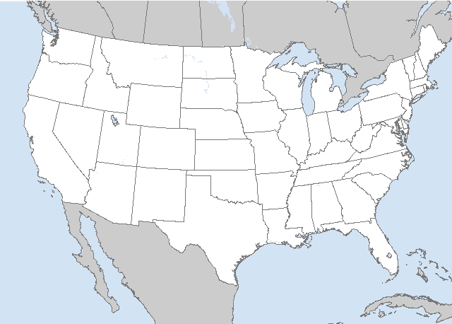
   SPC AC 030600

   Day 2 Convective Outlook
   NWS Storm Prediction Center Norman OK
   0100 AM CDT Fri May 03 2024

   Valid 041200Z - 051200Z

   ...THERE IS A SLIGHT RISK OF SEVERE THUNDERSTORMS ACROSS PARTS OF
   WEST TEXAS AND SOUTHEASTERN NEW MEXICO...

   ...SUMMARY...
   Scattered severe thunderstorms posing a threat for very large hail,
   damaging winds, and perhaps a few tornadoes should occur across
   parts of the southern High Plains Saturday afternoon and evening.
   Isolated strong to severe thunderstorms may occur across a broader
   portion of the southern Plains into the Ozarks, mid Mississippi
   Valley, and Midwest.

   ...Synopsis...
   A closed upper low will move east-southeastward over the western
   states on Saturday. Downstream, a shortwave trough will advance
   quickly east-northeastward across the Upper Midwest through the day.
   A related weak surface low should develop from IA towards IL in the
   same time frame. A cold front will extend southwestward from this
   low across parts of the mid MS Valley into the southern Plains. A
   subtle/low-amplitude shortwave trough is forecast to move across
   northern Mexico and the southern High Plains by late Saturday
   afternoon. This feature may provide sufficient lift to support
   isolated to scattered severe thunderstorms across parts of the
   southern High Plains Saturday afternoon/evening.

   ...Southern High Plains...
   A weak surface low should be in place over parts of far west TX and
   north-central Mexico through the day, with a dryline extending
   southward from this low. A southward-moving cold front should
   eventually intersect the dryline by late Saturday afternoon. Diurnal
   heating of a very moist low-level airmass and steep mid-level lapse
   rates will contribute to moderate/locally strong instability across
   west TX and southeastern NM. Convective initiation appears likely
   along both boundaries Saturday afternoon and evening. Although
   low-level flow should remain rather weak through the day, a
   favorably veering and slowly strengthening wind profile with height
   through mid levels will support around 35-45 kt of deep-layer shear.
   Robust thunderstorms that develop should quickly become
   supercellular and pose a threat for very large hail. Occasional
   severe/damaging downdraft winds may also occur. The tornado threat
   should be modulated to some extent by weak low-level flow and modest
   0-1 km shear through much of the afternoon. Still, a few tornadoes
   appear possible towards Saturday evening with any persistent
   supercell as an easterly low-level jet strengthens. A Slight Risk
   has been introduced across parts of west TX and southeastern NM
   where confidence is greatest in supercells occurring.

   ...Midwest/Mid Mississippi Valley to the Ozarks/Southern Plains...
   A line of strong to locally severe thunderstorms may be ongoing at
   the start of the period Saturday morning along or just ahead of the
   cold front, extending from IA into eastern KS. Even with a nocturnal
   minimum in instability, occasional damaging winds may occur with
   this line before it eventually weakens by late morning. Eventual
   redevelopment appears probable across parts of the mid MS
   Valley/Midwest by Saturday afternoon, as daytime heating ahead of
   the front fosters weak to moderate MLCAPE. Deep-layer shear appears
   marginal to support organized convection (around 25-30 kt). But,
   some small clusters may consolidate and pose an isolated threat for
   damaging winds and hail as they spread eastward across parts of the
   Midwest through Saturday afternoon, before slowly weakening Saturday
   evening with the loss of daytime heating.

   There also appears to be some chance for convection across west TX
   to spread eastward across much of OK/TX Saturday evening/night as
   the weak shortwave trough continues eastward across these areas.
   With moderate to strong MUCAPE present along/south of the cold
   front, some of this activity could pose a continued threat for
   isolated severe hail and gusty winds.

   ..Gleason.. 05/03/2024

   CLICK TO GET WUUS02 PTSDY2 PRODUCT

   NOTE: THE NEXT DAY 2 OUTLOOK IS SCHEDULED BY 1730Z


 @NWSSPC